
History
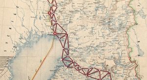
Struve Geodetic Arc is a chain of survey triangulations, a method created by a German-born astronomer Friedrich George Wilhelm Struve. The survey was carried out to measure the exact size and shape of planet Earth through a chain of triangulation measurements. The method was established and the measurements carried out in the first half of 19th century. The original arc consisted of 258 main triangles with 256 main station points, reaching all the way from Ukraine to Norway: there are station points in as many as ten countries (Norway, Sweden, Finland, Russia, Estonia, Latvia, Lithuania, Belarus, Ukraine, Moldova). The chain is the first World Heritage Site to comprise such a large number of countries.
Triangulation
Triangulation is based on the tracing and measurement of a network of triangles; one side of each triangle is measured, its angles deduced, as well as the other two sides by observation from this baseline. The triangulation results have been surprisingly precise and they have helped gain new data on the planet’s shape and size. The results have, among other things, been applied on mapping the regions. Struve geodetic arc was one of the most remarkable scientific inventions of its time. After that, the GPS has replaced triangulation.
The inscription of Struve geodetic arc on the list of UNESCO World Heritage Sites
Struve geodetic arc was inscribed on the list of UNESCO World Heritage Sites in 2005, when altogether 34 station points were established as sites to be preserved and protected. Six of these points are located on Finland, one of them being Puolakka station point on Oravivuori hill in Korpilahti. Struve geodetic arc represents the cultural heritage of science and technology.
In all the ten countries covered by the chain, there are altogether 34 station points that are protected by UNESCO. The other Finnish station points of the arc are located in Pyhtää (Mustaviiri), in Porlammi in Lapinjärvi (Tornikallio), in Tornio (Alatornio Church), in Ylitornio (Aavasaksa), and in Enontekiö (Stuorrahanoaivi).
A list of station points in other countries with locations:
Norway: Fuglenaes (Hammerfest), Lille-Reipas (Alattio), Lohdizhjokki and Bäljatz-vaara (Kautokeino)
Sweden: Pajtas-vaara (Kiruna), Kerrojupukka (Pajala), Pullinki (Övertorneå) and Perra-vaara (Haparanda)
Russia: Mäki-päälys (Mäkiinpäällys), Hogland, Totška Z (Gogland)
Estonia: Voibifer (Võivere), Katko (Simuna), Dorpa (Tartu)
Latvia: Sestu-Kalns (Sausneja), Jacobstadt (Jekabpils)
Lithuania: Karischki (Panemunélis), Meschkanzi (Nemenčinė), Beresnäki (Nemezis)
Belarus: Tupischki (Ašmjany), Lopati (Zelva), Ossownitza, Leskowitschi and Tchekutsk (Ivanava)
Moldavia: Rudy (Rudi)
Ukraine: Katerinowka (Antonivka), Felschtin (Hvardiisk), Baranowka (Baraniwka), Staro-Nekrassowka (Stara Nekrasivka)
Norja: Fuglenaes (Hammerfest), Lille-Reipas (Alattio), Lohdizhjokki ja Bäljatz-vaara (Kautokeino)
Ruotsi: Pajtas-vaara (Kiiruna), Kerrojupukka (Pajala), Pullinki (Ylitornio) sekä Perra-vaara (Haaparanta)
Venäjä: Mäki-päälys (Mäkiinpäällys), Hogland, Totška Z (Suursaari)
Viro: Voibifer (Võivere), Katko (Simuna), Dorpa (Tarto)
Latvia: Sestu-Kalns (Sausneja), Jacobstadt (Jekabpils)
Liettua: Karischki (Panemunélis), Meschkanzi (Nemenčinė), Beresnäki (Nemezis)
Valko-Venäjä: Tupischki (Ašmjany), Lopati (Zelva), Ossownitza, Leskowitschi ja Tchekutsk (Ivanava)
Moldova: Rudy (Rudi)
Ukraina: Katerinowka (Antonivka), Felschtin (Hvardiisk), Baranowka (Baraniwka), Staro-Nekrassowka (Stara Nekrasivka